原始文档
GPT Image 2 · en
{
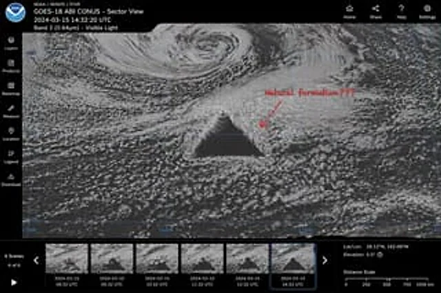
  "type": "Satellite image web interface model",
  "main_display": {
    "imagery": "A grayscale satellite view of ocean clouds, with a central point containing a{argument name=\"anomaly shape\" default=\"Huge, perfect geometric dark triangle\"}",
    "annotation": "The red handwritten text{argument name=\"annotation text\" default=\"Naturally formed?\"} The text is accompanied by a red arrow pointing to the anomaly.",
    "overlay": "The light blue latitude and longitude grid lines have coordinate labels such as 40N, 30N, and 160W."
  },
  "ui_layout": {
    "top_header": {
      "left_section": "The NOAA logo, with the words \"{argument name=\"satellite name\" default=\"GOES-18 ABI CONUS - Sector View\"} \"{argument name=\"timestamp\" default=\"2024-03-15 14:32:20 UTC\"} \"and \"Band 2 (0.64µm) - Visible light\"",
      "right_section": "The four navigation icons are labeled: Home, Share, Help, and Settings."
    },
    "left_sidebar": {
      "count": 7,
      "items": [
        "Layers",
        "product",
        "Base map",
        "Measurement",
        "Location",
        "legend",
        "download"
      ]
    },
    "bottom_panel": {
      "timeline": {
        "controls": "Play button, left and right arrows, text \"6 scenes\", \"6/6\"",
        "thumbnails": {
          "count": 6,
          "description": "Continuous satellite imagery showing the anomalous evolution, including hourly timestamps from 08:32 UTC to 14:32 UTC."
        }
      },
      "data_readout": {
        "coordinates": "{argument name=\"coordinate text\" default=\"Latitude and longitude: 28.12°N, 162.08°W\"}",
        "elevation": "Altitude: 0.5°",
        "scale": "Distance scale from 0 to 1000 km"
      }
    }
  }
}
使用方法
- 复制完整原始提示词,并保留其中的参数。
- 按需求替换主体、文字和构图要求。
- 在兼容的外部工具中使用,核对当前使用条件并检查结果。
开始前需了解
- 先确认是否需要参考图。标注兼容模型,不代表该示例由这个模型生成。
- 核对名称、数字与画面文字;不同模型版本的结果可能不同。